
Okello, Jacob Okomo
Frontend Software Engineer
GIS & Mobile Developer
DevOps Advocate
About Me
I'm Jacob Okello Okomo, an acclaimed and well celebrated Frontend Software Engineer, Mobile Developer & DevOps practitioner.
Mr. Okello Jacob Okomo,is a well reputed and publically celebrated Frontend & Mobile Software Engineer, who has developed, maintained and deployed complex Frontend Software in the past 2 years in both small to medium teams. As well, has previously developed & shipped Cross-platform Mobile Apps from Scrath to deployemnt, putting in place well-accepted DevOps standards & best practices. Academically, he is a holder of the highly coveted First Class Honours in Bsc. GIS from the well-thought-of Jomo Kenyatta University of Agriculture and Technology-JKUAT.
I'm highly confident with iterating through the AGILE Software Developemnt Life-Cycle.
Professional Developement: 2 Yrs
Website : Click here
Email : okomo.code@gmail.com
Degree : Bsc. GIS and RS
Phone : +254705-583-483
City : Nairobi
Frontend Software Developement
DevOps | VCS | Docker | CI/CD | Jenkins
Mobile Developement
Education
March 2023 - Present, Harvard University
CS50: Introduction to Computer Science
Computer Science essentials
• Thinking algorithmically & efficient problem solving skills for Software Engineers.
Dec 2022 - 2023, Udemy
Data Structures & Algorithms.
DSA for Frontend Engineers
• Sharpening my Frontend & general problems
solving skills by writting efficient & quality
code.
• Systems Design patterns & SDE best practices.
2017 - 2022 - JKUAT, BSC.
Bsc(Eng). Geospatial Information Science.
First Class Honours
• Graduaated from Jomo Kenyatta University of Agriculture and Technology-JKUAT, in the Fuculty of Engineering and Technology.
Experience
Nov 2022 - Present: AVL RnD.
Frontend Software Engineer - FinTech
Techs: Angular, GitLab CICD, Docker, MkDocs
• Building complex UI & tests for a smooth
consumer UX
• Participating in SDLC from ideation to
deployment.
• Routine software & security updates & SEO.
• Shipping Frontend Apps to cloud, through CICD
pipelines
Jan 2023 - Present: ICT Authority of Kenya
Professional Software Engineering Mentor
Techs: Project Management, Code Reviews, Agile
SDLC, Systems Design & Patterns
• Instilling Software Engineering best practices,
architecture & design patterns to ICT interns &
Junior SDE.
Jan - June 2022; Ecospace Services Ltd.
Land Cover Data Collection Mobile App(Contract)
Techs: Flutter, PostgreSQL, NodeJS, Google Maps
APIs
• Led the team of 5 through scrum & Agile SDLC.
• Deeployed the 5 star app to
Google Play store
Services | Skills
Frontend Software Developement
• Builds high-quality & secure Web Apps for an stellar UX.
• Writing optimized test in Jasmine & Karma.
• Responsive Design & cross-browser compatibility.
• Horrizontal scaling to optimize web apps performance.
• Collaborating with other developers throughout Agile SDLC.
Mobile & GIS Developer
• Cross-platform mobile developement.
• Flutter SDK, testing & debugging.
• Mobile App Deployment to Google Play and Apple Store.
• Google Earth Engine, LeafletJS, GIS Database Mgt.
• Spatial Data Analysis, GIS Software & WebGIS Developement.
User Interface Design
• Wireframing high-quality interactive Web & Mobile
prototypes.
• Collaborate closely with the Design, Dev & Product Mgt
teams.
• Translating user requirements into sterning designs
DevOps, Version Control & Cloud
• Containerization & CI/CD pipeline automation.
• Software Version control using Git.
• Automatic deployment via GitHub actions, GitLab CICD.
Portfolio
Web & MobileGIS Dev for Land Cover Data Collection(Click to zoom).
ML for Trend Analysis and AI for Comp. Vision
Flutter & MobileGIS
Web GIS for Resource Monitoring.
Machine Learning & AI for Health
ML for Climate Action
Latest Blogs
Web & MobileGIS Data Collecter
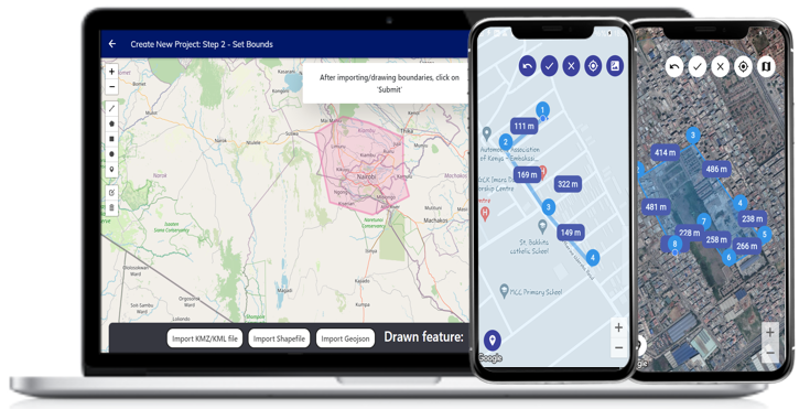
Have you ever dreamt or even imagined of carrying a whole Total Station in your pocket? Meet this cross-platform MobileGIS app that enambles a surveyor/ GIS personnel to efforltessly collect any spatial data (point, lines, polygons) in the field at their desired comfort. The geo-fenced MolibeGIS app enables the office-based project-admin to deploy the data collection team and monitors them work remotely within that geo-fenced region. More about this amazing technology is coming up...
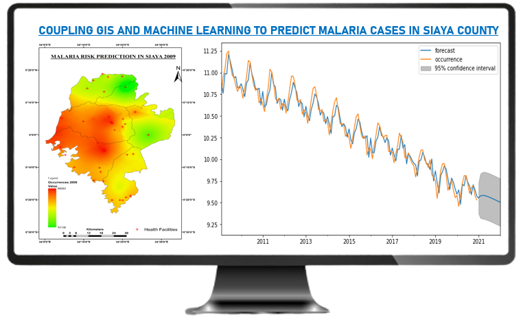
GIS & ML in Epidemiology
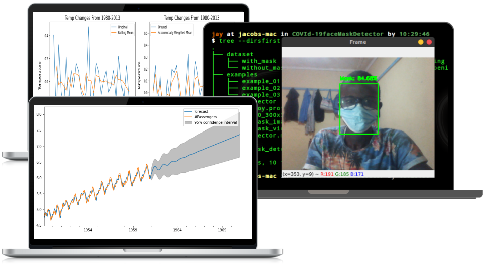
Employing GIS in epidemiological research has always catalysed the outcome as attested by Dr. John Snow's finding about Cholera in 1854. Predictive Machine Learning as an add-on elevates the experience higher. HIV/AIDS and Malaria has been subjecting the Ministries of Health especially in Kenya into great finacial jeopardy. Applying ML & GIS to monitor the behaviour & predict the spread provides a great avenue for informed decision making for effective deploying resources in a given affected zone.
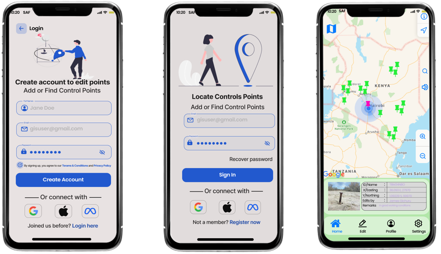
Mobile GIS in Surveying
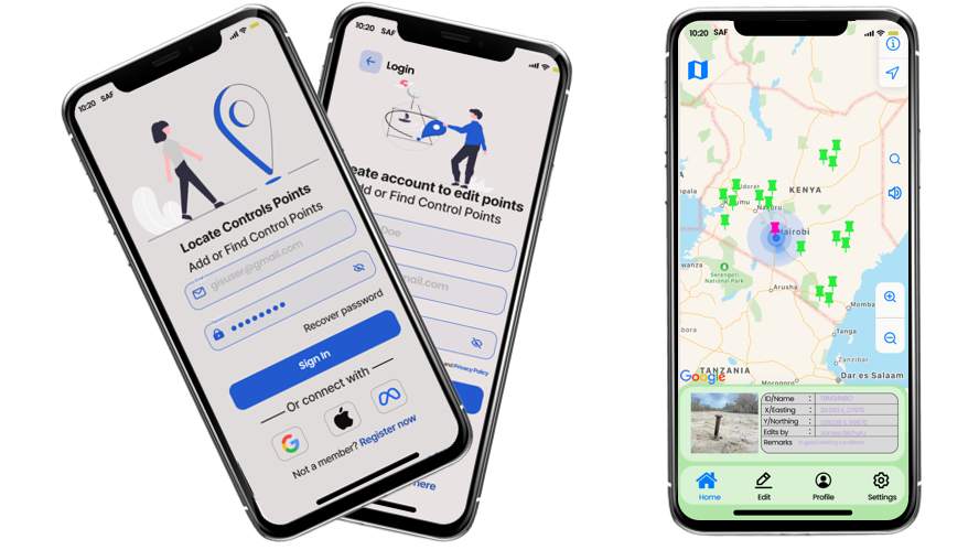
Occassionally, land surveyors are faced with this common problem of locating the nearest vertical Grounds Control Points(GCPs) from which they can transfer their traverses or say, levels. This cross platform MobileGIS app (Android and iOS) enables you to quickly spot the nearest GCP from your project location. Further you can edit the existing or add new control points, which are later subject to approval by the Surveyors of Kenya or any other mandated body for accuracy scrutiny. A web version is under developement too.
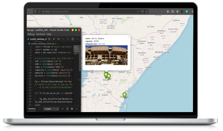
WebGIS for National Resources
A country like Kenya, is well endowed with both natural and built resources, that to some expent it might prove strenuous to seamlessly man them. Open Source WebGIS can be explored to gather, monitor, visualize and manage these and more resources both at local, regional and naionla level. This is a sample of how the Stadia in kenya e.g Moi Int'l Kasarani can be monitored using webGIS.
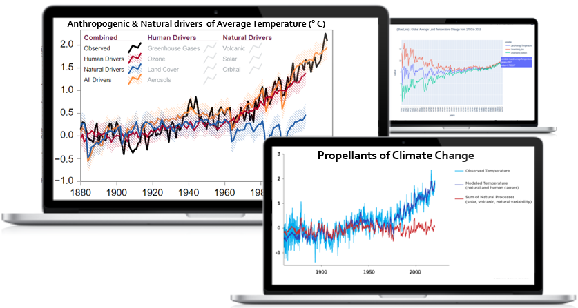
Climate Change Forecasting & AI
Can machines think?- Alan Turing, 1950. Well, prediction is nolonger only for the prophets or some devine beings! Climate emergency is worrying me, and you? Being able to model time series data for informed climate crisis forecast from the past trends is left to machines. LSTMs, ANN, GANS, CARTs, RFs just to list partially are my artificial eyes to preconcieve climate change.
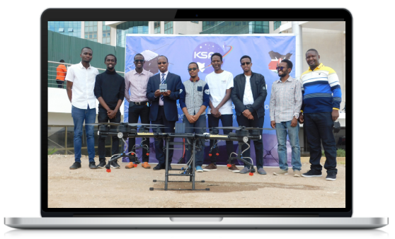
Nanosatellite Developement
Wait! So we just be there consuming third-party satellite data without deploying our own artificial eye into space to collect us first hand images? How can we then monitor our agricultural fields, forest & natural resources? My zeel for multi-discplinary & technical engagement saw us come up with a deployment-ready nanosatellite set to fill such gaps. The CubeSat is under upgrades for launch.
Contact Me
Call On
+254705-583-483
Office
Nairobi | Remote
okomo.code@gmail.com